 Goblin
The world map shows which countries your apps connect to. Each country gets a dot, sized by how much data went there, with an arc from where you are. It's a quick way to spot an app that talks to somewhere you didn't expect. The map lives in Connections. It's off until you turn it on, and Goblin remembers your choice.
Show the map#
- Open Goblin's window, click the Network tab and choose Connections.
- Click the Map button (the folded map icon) at the right end of the toolbar's first row. Hover shows "Show the map of where connections go".
- The map appears in the chart card, above the traffic chart. Its header reads "Destinations" with the number of countries.
- Click Map again to hide it.
The first time, Goblin downloads the location database (about 4 MB) so it can place each server. See The location database.
See which countries an app connects to#
- With the map showing, choose the app in the App menu in the toolbar's second row. The map shows only that app's countries.
- Hover a dot to read the country, the number of connections, the bytes and how many were denied.
- To widen the view again, set App back to All.
The map works with or without the firewall. It shows the same connections as the list, so the time range, search and filters apply to it too.
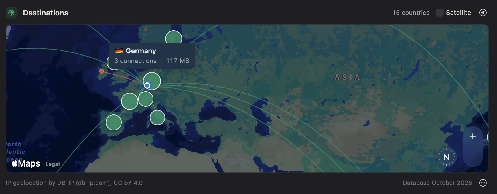
Reading the map#
- One dot per country. Its size grows with the bytes sent and received there, or with the number of connections when no bytes were measured.
- Arcs run from your location to each dot.
- Red dots and arcs mean every connection to that country was denied. A red ring and arc mean some were.
- Your location has its own marker. It also stands for your Local Network: click it to list only local connections.
- A Private Relay pin sits beside your location when connections went through iCloud Private Relay.
- Hover a dot for a callout with the country, the number of connections, the bytes and how many were denied.
The header reads "Destinations" with the number of countries. Use the zoom buttons and compass in the corner to move around.
Filtering by country#
- Click a dot on the map. The list filters to that country, the other countries dim, and a chip with the country's flag and name appears in the header.
- To see everything again, click the dot a second time, or click the chip's ✕ ("Show every country again").
To see only your own network, click your location marker.
Switch to satellite view#
- In the map's header, tick Satellite. The map switches to satellite imagery.
- Untick it to go back to a muted standard map.
Goblin remembers the choice.
Set your location#
- In the map's header, click the My Location button (a location arrow in a circle). The menu heading says whether the location is "set by hand" or your Mac's region.
- Move the map until its middle is where you are, then choose Set My Location to Map Centre. Or select a country and choose Set My Location to <Country>.
- Or choose Automatically Determine My Location to ask Location Services once. macOS asks for permission the first time; click Allow.
- To go back, choose Use <Region> (Mac's Region).
The arcs now start from your chosen place. Show All Destinations and Show Whole World in the same menu only move the camera.
Arcs start from your Mac's region, as set in macOS, unless you choose a place yourself. The My Location button (a location arrow in a circle) opens a menu. Its heading says whether the location is "set by hand" or your Mac's region.
| Item | What it does |
|---|---|
| Set My Location to Map Centre | Uses the middle of the map as you've moved it. |
| Set My Location to <Country> | Uses the country you've selected. Shown while one is selected. |
| Use <Region> (Mac's Region) | Goes back to your Mac's region. Available after you set a place by hand. |
| Automatically Determine My Location | Asks Location Services once for where you are. macOS asks for permission the first time. |
| Show All Destinations | Frames every dot. |
| Show Whole World | Zooms out to the whole world, centred on you. |
If Location Services is off, or Goblin isn't allowed to use it, the menu says so: "Location Services is off in System Settings." or "Allow Goblin in System Settings › Privacy & Security › Location Services." Your location stays on your Mac. It's only used to draw the arcs.
With the firewall on, Automatically update my location in map in Firewall settings (off by default) asks Location Services each time the map appears, so the arcs follow you when you travel.
The location database#
To place a server on the map, Goblin looks up its address in a small database of which addresses belong to which country. It uses DB-IP's free country database, about 4 MB, from db-ip.com. The lookups happen on your Mac: no address you connect to is sent anywhere to be located.
Download or update the database#
- Show the map. If automatic updates are on (the default), the download starts straight away and the footer reads "Updating…".
- If the map shows "See where connections go", click Download Geolocation Database (or Try Again after a failure).
- To fetch a newer edition yourself, click ⋯ in the map's footer and choose Update Database Now. Or open Settings›Firewall›Monitor and click Check for Update under Map.
When it worked, the footer reads like "Database October 2026" and dots appear.
The database downloads by itself the first time you show the map. With Update Automatically on (the default), turning on the Map downloads it from download.db-ip.com straight away. After that, Goblin refreshes it about once a month: when the copy is more than 32 days old and you show the map, it fetches the new edition. If an automatic download fails, Goblin waits a day before trying again.
- It's saved in
~/Library/Application Support/Goblin/GeoIP/. - Private, local and multicast addresses are never looked up. They show as Local Network.
- With the firewall on, the built-in Goblin rule group allows Goblin to reach db-ip.com, so your rules don't block the download.
- The map itself, the land and the satellite pictures, comes from Apple Maps, like the map in any Mac app.
The map's footer credits the source ("IP geolocation by DB-IP (db-ip.com), CC BY 4.0") and shows the edition, such as "Database October 2026", or "Updating…" while it downloads. A ⚠ appears if the last update failed; point at it to read why.
Turning automatic downloads off#
Use either place:
- Click ⋯ in the map's footer and turn off Update Automatically. You can still fetch a new edition yourself with Update Database Now in the same menu.
- With the firewall on, turn off Update the geolocation database automatically in Firewall settings under Monitor›Map. The same pane shows the edition and when it was checked, with a Check for Update button.
Both switches are the same setting. The ⋯ menu only appears once a database is installed, so if you don't want the first download at all, leave the Map off, or turn the setting off in Firewall settings before you show the map.
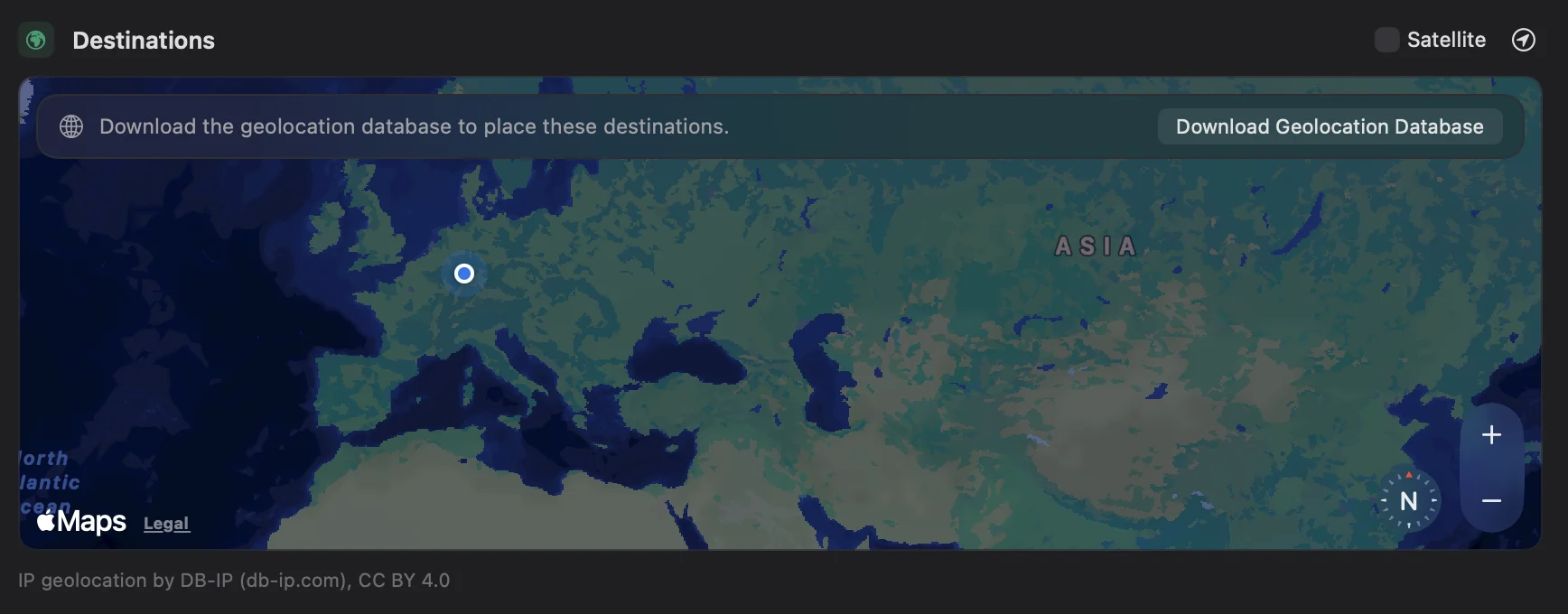
When there's no database and automatic updates are off, or the download failed, the map shows "See where connections go" with a Download Geolocation Database button (or Try Again). A smaller version of the prompt sits on top of the map when some destinations can already be placed, such as your local network.
“Review Network Map Location latitude,longitude” validates finite coordinate bounds and prepares native review. “Review Determine Network Map Location” keeps native Location Services authorization; the result remains pending until Read Network Map Location reports it. “Reset Network Map To Mac Region” restores the native region. “Review Update Network GeoIP Database” downloads the native database after confirmation; a confirmed download can continue after cancellation. Read Network Monitor Review reports completion or failure.
“List Open Network Maps” returns currently mounted view UUIDs. “Frame Open Network Map <UUID> | destinations” requests native Show All Destinations; use world for Show Whole World. These request camera framing, without claiming animation completion. “Review Network Map Origin At Visible Center <UUID>” requires the same mounted view and unchanged current center at confirmation. “Review Network Map Origin At Country <code>” uses the native centroid of a current country code from List Network Monitor Options. “Set Network Map Satellite on/off” and “Set Automatic Network GeoIP Updates on/off” change and read back their native preferences. Map identities expire when their view closes.